


Guthrie Voting District, Callaway County, Missouri
About
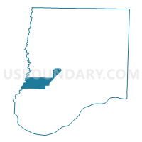
Outline

Summary
| Unique Area Identifier | 607311 |
| Name | Guthrie Voting District |
| County | Callaway County |
| State | Missouri |
| Area (square miles) | 23.61 |
| Land Area (square miles) | 23.41 |
| Water Area (square miles) | 0.20 |
| % of Land Area | 99.16 |
| % of Water Area | 0.84 |
| Latitude of the Internal Point | 38.77573850 |
| Longtitude of the Internal Point | -92.09506980 |
Maps


Graphs
Select a template below for downloading or customizing gragh for Guthrie Voting District, Callaway County, Missouri


Neighbors
Neighoring Voting District (by Name) Neighboring Voting District on the Map
- Voting District 29, Boone County, MO
- Voting District 30, Boone County, MO
- Voting District 31, Boone County, MO
- Carrington Voting District, Callaway County, MO
- Dixie Voting District, Callaway County, MO
- East Fulton Voting District, Callaway County, MO
- Fulton No. 3 Voting District, Callaway County, MO
- New Bloomfield Voting District, Callaway County, MO
- West Fulton Voting District, Callaway County, MO
Top 10 Neighboring County Subdivision (by Population) Neighboring County Subdivision on the Map
- East Fulton township, Callaway County, MO (10,231)
- West Fulton township, Callaway County, MO (7,269)
- Three Creeks township, Boone County, MO (5,133)
- Cedar township, Boone County, MO (4,190)
- Cedar township, Callaway County, MO (2,937)
- Round Prairie township, Callaway County, MO (1,038)
- Guthrie township, Callaway County, MO (604)
- Caldwell township, Callaway County, MO (438)
Top 10 Neighboring Place (by Population) Neighboring Place on the Map
Top 10 Neighboring Unified School District (by Population) Neighboring Unified School District on the Map
- Fulton School District, MO (19,130)
- Southern Boone County R-I School District, MO (7,932)
- South Callaway R-II Schools, MO (4,457)
- New Bloomfield R-III School District, MO (4,232)
Top 10 Neighboring State Legislative District Lower Chamber (by Population) Neighboring State Legislative District Lower Chamber on the Map
Top 10 Neighboring State Legislative District Upper Chamber (by Population) Neighboring State Legislative District Upper Chamber on the Map
Top 10 Neighboring 111th Congressional District (by Population) Neighboring 111th Congressional District on the Map
Top 10 Neighboring Census Tract (by Population) Neighboring Census Tract on the Map
- Census Tract 17.01, Boone County, MO (6,909)
- Census Tract 706, Callaway County, MO (6,426)
- Census Tract 705, Callaway County, MO (4,999)